The World's Craziest Roads
Surveying the twisted tarmac zigzagging below its summit from the cockpit of his Aston Martin DBS, he chuckled with pure delight, exclaiming to the camera, “That’s the most amazing road I’ve ever seen!” If he’d had a tail, it surely would have been wagging.
This serpentine motorway is just one of many mind-bogglingly crazy roads around the globe. And these exciting—albeit potentially perilous—paths offer travelers a refreshing diversion in an era of monotonous interstates and traffic-controlling roundabouts. From the seemingly insurmountable Alps to the craggy coastline of the Amalfi, the steep hills of New Zealand to the arctic expanses of northern Canada, dramatic geography has left us with some of the world’s more brilliantly engineered pieces of pavement.
Or not so brilliantly engineered. Take, for instance, Bolivia’s ill-conceived Yungas Road, a rickety route connecting the high-altitude capital of La Paz with the low-elevation rainforest town of Coroico. This dangerous pass poses such a harrowing journey (largely unpaved, single lane, no guardrails, 2,000-foot drops) that it claims an estimated 200 drivers’ lives annually, rightfully earning it the nickname El Camino de la Muerte (“The Road of Death”).
Back in Romania, the Transfăgărăşan’s own bloody history began with its creation. Built in the 1970s under President Nicolae Ceauşescu as a means to mobilize armed forces in the event of a Soviet invasion, this roadway—connecting the remote regions of Transylvania and Wallachia in an endless series of bends, tunnels, and viaducts—exists at the cost of six thousand tons of dynamite and 40 road workers’ lives. Dracula might have approved, but to this day locals bitterly refer to the highway as “Ceauşescu’s Folly.”
Given those figures, Bolivian bus tours and Transylvanian road trips might not top your to-do list. But the next time you’re zoning out in cruise control or find yourself verbally engaging the Garmin GPS’s female navigator just to stay awake, think of the demanding, dangerous, and downright crazy roads ahead. Then thank your lucky stars for the carpool lane.

Passo dello Stelvio, Italy
The Road: Topping out at just over 9,000 feet, Italy’s Passo dello Stelvio is the second highest mountain pass in the Alps and—thanks to 48 tightly coiled hairpin turns—arguably the most spectacular. Scaling the northern side in a seemingly never-ending series of nauseating swoops, this ribbon of asphalt, which dates to the 1820s, winds past craggy rock outcroppings and underneath an overhanging glacier en route to the summit.

The reward: acres of lift-serviced skiing atop the Stelvio glacier, even in the dead of summer.
Insider Tip: Always look ahead; if the route is clear of any oncoming traffic, briefly drift out into the opposite lane before banking back into your own—you’ll cut the 180-degree bend at its apex and enjoy a much more fluid drive.

Going-to-the-Sun-Road, Glacier National Park, MT
The Road: The 53-mile, two-lane Going-to-the-Sun-Road spans one of America’s most ambitious national parks.

And come summer, visitors can drive the route, providing the National Park Service’s plows have cleared the 80 feet of snow that blanket Logan Pass each year, a task that can take up to 10 weeks to complete.
Insider Tip: Instead of driving directly through the park, take a detour to the Many Glacier Hotel (doubles from $142), a historic post-and-beam lodge on the mountain-flanked shores of Swiftcurrent Lake.

Tremola, Switzerland
The Road: As if navigating Switzerland’s frantic Gotthard Pass—a nearly 7,000-foot-high mountain route connecting the picturesque village of Andermatt with the Italian-speaking canton of Ticino—wasn’t tricky enough, the timeless Tremola throws 37 switchback turns into the mix and adds countless cobblestones.

It’s a favorite thrill among touring motorcyclists, who rank its bumpy bends as Europe’s toughest.
Insider Tip: This road is all about the view, so skip the drive and book a traditional horse-drawn coach in Andermatt; you’ll enjoy the Alpine panorama at a leisurely, risk-free pace.
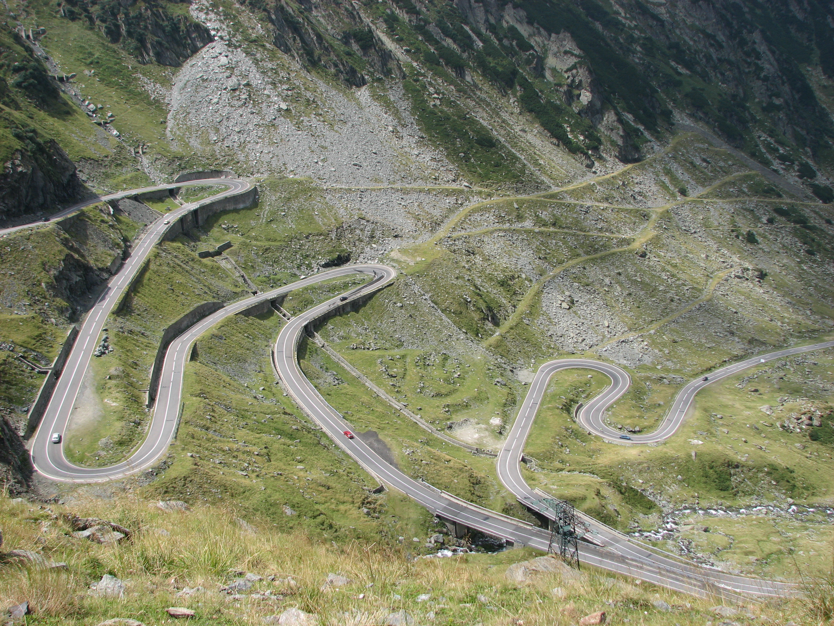
Transfăgărăşan Highway, Romania
The Road: Last year, the cheeky hosts of British automotive show Top Gear dubbed this twisting, 55.8-mile road the world’s greatest driving road. Just don’t let the word highway fool you—the Transfăgărăşan is no straight-shot freeway.
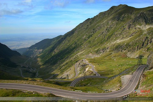
A former military road built through Romania’s Carpathian Mountains to expedite mobilization in the event of a Soviet invasion, the Transfăgărăşan features dimly lit tunnels, narrow viaducts, and hairpin turns skimming the edges of plunging cliffs as it passes through Transylvania (cue maniacal Dracula laughter).
Insider Tip: Take in the spectacular scenery and undulating asphalt from the bucket seat of a convertible—preferably one with some horsepower.

Baldwin Street, New Zealand
The Road: This imposing concrete slab skyrockets out of the sleepy South Island town of North East Valley and gains 232 feet in just over two-tenths of a mile, making it the world’s steepest street.
To put things in perspective, consider this: San Francisco’s famed Filbert Street never exceeds 31.5 percent in gradient, while Baldwin maxes out at a neck-craning 35 percent.
Insider Tip: If your car sounds like it’s straining in first gear to climb this steep pitch, imagine how your legs would fare. Test the strength of your human engine at the annual Baldwin Street Gutbuster held every February, where athletes race up and down the infamous hill and winners finish the 700-meter sprint in less than two minutes.

Yungas Road, Bolivia
The Road: If a route’s drama is measured by extreme danger, then Bolivia’s Yungas Road might well be the ultimate mountain pass. Nicknamed El Camino de la Muerte (“The Road of Death”), thanks to the more than 200 lives it claims each year, the harrowing journey from Bolivian capital La Paz to the rainforest town of Coroico has enough zero-error zones to make even Indiana Jones question his rental car’s GPS.
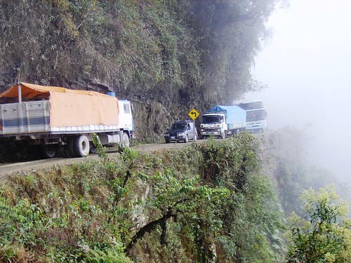
Though only 38 miles in length, the single-lane route is packed with pitfalls: dirt surfaces, frequent rainstorms, a 15,000-foot summit, and nothing even remotely resembling a guardrail between you and the 2,000-foot cliffs.
Insider Tip: Never drive this route. If you need reasons, please reread the paragraph above.

Ice Roads, Northwest Territories, Canada
The Road: The whole concept of creating a seasonal motorway atop a frozen body of water—especially one that might crack at any minute—is downright frightening.

But that hasn’t deterred Canada’s ice truckers, who navigate their big rigs through snow drifts and over sheets of ice to transport supplies across the Northwest Territories, an inhospitable winter wasteland (which means no, AAA does not provide roadside service).
Insider Tip: Unless you’re lured by the be-your-own-boss possibilities of mushing an 18-wheeler through the Great White North, we suggest staying put this winter and working through the first season of the History Channel’s Ice Road Truckers on DVD.

The A81, Gottmadingen to Weinsberg, Germany
The Road: Though touted as the world’s fastest, speedometer-maxing highway, large sections of the German Autobahn are in fact subject to strict speed limits. One glorious exception is the 121 miles of asphalt between Gottmadingen and Weinsberg.

Cutting a path past farms, vineyards, and medieval villages, this unregulated and rarely congested section of highway provides everyman speed-demons with pure, pedal-to-the-metal pleasure.
Insider Tip: Rent a Porsche 911 and you’ll be in good company—testers from the sports car behemoth’s nearby Stuttgart factory frequently use the road to assess their fleet’s handling capabilities.

Highway 99, the Sea-to-Sky Highway, British Columbia
The Road: Hugging a cliff high above the fjordlike Howe Sound, this 63-mile northern section of Highway 99—which connects

Vancouver and Whistler—ascends through a veritable layer-cake of climates, winding along craggy coastlines and past lush, Pacific Northwest rainforest, before ending in Whistler’s natural amphitheater of glacially capped peaks.
Insider Tip: En route to Whistler, stop by the logging town of Squamish and check out Shannon Falls, a waterfall whose silvery plume plunges more than 1,000 feet.

The Amalfi Coast, Italy
The Road: Never ones to sacrifice drama in favor of logic, Italian road engineers ringed the sheer cliffs of the Sorrento Peninsula with wiggly lanes of asphalt.

Teetering high above the azure Mediterranean waters, this narrow motorway weaves in and out of terraced towns and tests drivers’ handling skills as they’re forced to hug rocky bends and shimmy past fearless oncoming drivers. Viva the Amalfi, where the views are spectacular but the corners are blind!
Insider Tip: Of the picturesque towns dotting the route, none is more romantic than Ravello, whose pristine white duomo, vibrant gardens, and unparalleled views of the sea are sure to keep your heart racing long after you’ve had the courage to unfasten your safety belt.

Passage du Gois, France
The Road: Linking the island of Noirmoutier to the mainland town of Beauvoir-sur-Mer in western France, the Passage du Gois is a 2.58-mile paved sandbar that’s flooded twice a day at high tide. When it isn’t submerged, this narrow causeway—flanked by fishing boats and littered with errant clumps of seaweed—is a slippery stretch indeed and especially treacherous on two wheels: in 1999, a domino-effect spill took down nearly half of the Tour de France’s peloton.
Insider Tip: Crossing is permitted only during the three-hour window surrounding low tide.
World's Scariest Roads

North Yungas Road, Bolivia
Location: Between La Paz and the town of Coroico
Fear factor: In running as the most dangerous road on the planet, the North Yungas Road—aka the “Road of Death”—stretches for some 40 mountain-hugging miles, as narrow as 10 feet in spots and with 1,000-foot drops straight to a rainforest below.

Guardrails? You only wish.

Guoliang Tunnel Road, China

Location: China’s Taihang Mountains
Fear factor: Let’s just say its name translates to the “Road that does not tolerate any mistakes.” In 1972, villagers in a remote area of the Taihang Mountains chiseled a 3/4-mile-long tunnel through a mountain for access to the outside world.
Today, the route—15 feet high and 12 feet wide—is a tight squeeze for vehicles, twisting past the tunnel’s 30 “windows,” which provide views off the precipice to a tumbling abyss hundreds of feet below.

Halsema Highway, Philippines

Location: Island of Luzon
Fear factor: Like many under-maintained mountain roads, landslides are a hazard on the Halsema Highway, where big stones and debris tumble from peaks. And along with the cloud forests comes mist that can ruin visibility.
Tracing a circuitous path, this road crosses the massive Cordillera Central mountain range on the Island of Luzon, and many sections remain unpaved.

Karakoram Highway, Pakistan to China
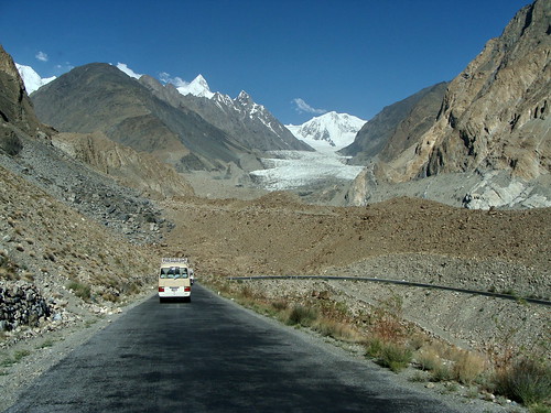
Location: Karakoram mountain range in Pakistan
Fear factor: The highest paved road on the planet, the Karakoram Highway winds through the mountains at an altitude above 16,000, eventually connecting to China. It’s a popular tourist route, with motorists stopping to view K2 and other stratosphere-scraping peaks from the pavement.
Drivers can easily suffer altitude sickness on the 800-mile highway, which slinks along rivers and crosses arid planes before climbing the endless inclines of the Karakoram.

Kolyma Highway, Russia

Location: Russian Far East and Siberia
Fear factor: Actors Ewan McGregor and Charley Boorman traversed this 1,200-mile route, nicknamed the Road of Bones, on a round-the-world motorcycle journey in 2004. Constructed in the Stalin era, the Road of Bones gets its name from labor camp inmates and other workers who died during construction, some of whom are buried beneath or near the road. This wilderness route runs past some of the coldest inhabited places on earth.
In winter, motorists drive across ice on frozen rivers in lieu of ferries.

Canning Stock Route, Australia

Location: Through the vast deserts of Western Australia
Fear factor: Cattlemen 100 years ago pushed this 1,100-mile route through the endless deserts of Down Under, digging more than 50 wells along its length.
Recreational four-wheel-drive convoys can now cross the desolation with the aid of fuel drops, forging endless sand and sun-baked earth to traverse one of the least inhabitable places on the planet.

Graciosa Trail, Brazil


Location: In the mountains above Morretes
Fear factor: This old mule route winds through a rainforest and crosses moss-covered bridges. Cobblestone paves parts of its length, slippery and dangerous on the route’s sharp turns, and hydrangea plants push in to line the lush lane with blue flowers.

Trans-Sahara Highway, Africa

Location: Algiers, Algeria to Lagos, Nigeria
Fear factor: From pavement to sand, the 2,800-mile Trans-Sahara Highway traverses three countries—Algeria, Niger, and Nigeria—on its journey through the largest sand desert on Earth.
Fuel and water are unavailable for much of its sun-scorched length, and sand storms some years move immense drifts and dunes onto the road, blocking the route for days at a time.

The Stilwell Road, India and Burma

Location: Jungle route from Ledo, India into Burma
Fear factor: Built during World War II at the cost of thousands of lives, the Stilwell Road (aka The Ledo Road) climbs mountain passes, snakes through the jungle, and crosses more than 100 rivers and streams in its 1,079-mile length.
Constructed as a supply route by Western Allies, the road today is returning to jungle, little used and inaccessible for much of its length behind Burma’s totalitarian curtain.

Wilderness Road to Selva Blue Lodge, Bolivia

Location: Between Santa Ana and the Selva Blue wilderness lodge
Fear factor: The route, a 100-mile jungle labyrinth, is a 20-foot-wide gravel track that shrinks to a grassy two-track and crosses log bridges over rushing Amazonia tributaries. The Caravana motorcycle festival chose this often-flooded route through the Amazon Basin of northern Bolivia in 2002.
3 comments:
Super
Nice collection, however you left out the Tianmenshan road. Picture of the Stelvio brought me here.
Very nice. Thank you for posting...
Post a Comment